
How far away can you go from the sea in each European country? And which town or village is the one furthest from the sea? An interesting question, for which it might be harder to find an answer than you think. But fear not, at Landgeist we’ve done the research and have been able to answer that question. For every country in Europe, we’ve calculated which settlement is furthest from the sea.

Like this map and want to support Landgeist? The best way to support Landgeist, is by sharing this map. When you share this map, make sure that you credit Landgeist and link to the source article. If you share it on Instagram, just tag @Land_geist. On X / Twitter tag @Landgeist.
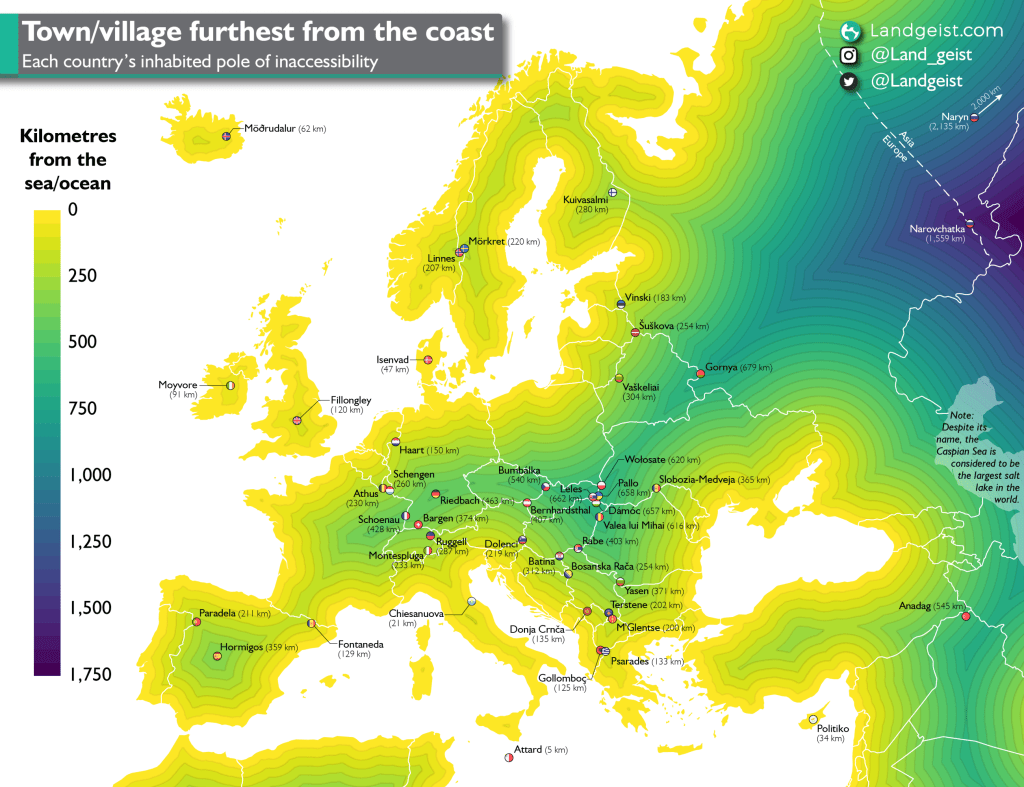
The point on land that is furthest from the sea, is called the pole of inaccessibility. Normally this is calculated for a continent or island. For this map, we didn’t calculate the exact point of inaccessibility, but the village or town that is furthest from the coast. There’s no real name for it yet, so let’s call it the inhabited pole of inaccessibility. For most European countries, their pole of inaccessibility and their inhabited pole of inaccessibility are at the same location or very close to one another. The only exception is Iceland. Due to its inhospitable volcanic and rough nature, there are no settlements in Iceland’s interior. The pole of inaccessibility and the inhabited pole of inaccessibility, lie about 150 km (93 mi) away from each other in Iceland.
The coastline paradox
Before you get all excited, I have to let you know that for some countries the pole of inaccessibility varies slightly depending on what definition of a coastline you use. These are mostly the countries closer to the coast or on an island.
Now you might be thinking, the definition of where the coast is, is pretty clear, right? Well, no. This is what’s called the coastline paradox. It’s the counter-intuitive observation that the coastline of a landmass does not have a well-defined length. It strongly depends on the method used to measure the coastline and the degree of cartographic generalization.
Furthermore, it’s also not very clear where the sea starts and ends. First of all, where the sea meets the land constantly changes because of the tides. Then there are other problems, like where does a river exactly meet the sea? How about tidal rivers? How about tidal plains?
Is the Caspian Sea actually a sea?
These questions bring one very large and interesting body of water to light, the Caspian Sea. Its name suggests that it’s a sea. But this is still highly debated. The Caspian Sea is called a sea, because when the Romans discovered it, they assumed it was a sea because of its high salinity and vast size. Despite its salinity, it’s still not as salty as an actual sea. Its salinity is more like that of a salt lake. Furthermore, it’s not connected to the open seas. So, despite its name, the Caspian Sea is often regarded to be the largest salt lake in the world. Because of that, it’s not included in the calculations as a sea. This only had an effect on the result for Turkey and the European part of Russia.
So, depending on what definition of the coastline you use, you could end up with a slightly different result. Although this result won’t be widely different from this map and in most cases will be the same.
Methodology
So how did I go about the calculations for this map? For this calculation, the GADM coastline dataset was used. It’s one of the most detailed freely available files of the world’s coastlines out there. Making it a great choice for accurate calculations. I’ve made some small changes to the coastline here and there, after checking it with the satellite image. A distance calculation was made from the coastline in QGIS to see which settlement is located furthest from the sea in a linear distance.
A settlement is another feature that is not as well defined as one might think. When is something a settlement and when is it just a handful of houses or farms in the countryside that are coincidentally close to each other? Because of that, I decided to only include settlements with a population of 10 people or more. If the population was unknown, I would include the settlement if, based on satellite images, I could safely assume there are at least 10 people living there. The final results are the settlements on this map.
Europe’s inhabited poles of inaccessibility
The furthest point in all of Europe, is located in Russia. A village called Narovchatka, near the city of Magnitogorsk. The village is located on the Ural river, which at that location, forms the border between Europe and Asia. From Narovchatka one has to travel 1,559 kilometres (969 mi) to reach the coast. Russia’s inhabited pole of inaccessibility is located 2000 km eastwards in the Asian part of Russia. It’s the village of Naryn, near the border with Mongolia, which is 2,135 kilometres (1,327 mi) from the nearest sea or ocean.
The inhabited pole of inaccessibility of the EU is the Slovakian village of Leles, 662 (411 mi) kilometres from the nearest coast.
Most of the names on this map might not sound familiar to you. Which isn’t too surprising, as most of them have a population under 10,000 inhabitants. However, there are definitely some very interesting places on this map, some that you have heard of and some you haven’t. Let’s have a look at some.
Attard, Malta
Distance from the coast: 5 km (3 mi)
Population: 11,377

Located in the centre of Malta island, Attard is closest to the coast of all the inhabited poles inaccessibility. Located only 5 kilometres from the coast, it’s closer to the coast than the vast majority of towns in Europe. Attard is part of the ‘Three Villages’, together with Balzan and Lija.
Attard is known for its many flower gardens and citrus orchards. Attard’s motto shows how proud the people of Attard are of their flower gardens: Florigera rosis halo (“I perfume the air with my blossoms”).
Attard is home to San Anton Palace. A palace originally built in the 17th century for Antoine de Paule, a knight of the Order of St. John. Since 1974, it serves as the official residence of the president of Malta.
Politiko (Πολιτικό), Cyprus
Distance from the coast: 34 km (21 mi)
Population: 369

Located in the centre of Cyprus, Politiko is a small village with a big history. Politiko was once home to the ancient city kingdom of Tamassos. After the discovery of copper in the area, the villages in that area grew into a city, which became Tamassos. The copper mines became the heart of Tamassos economy, which boosted the growth of this kingdom.
Famous writers such as Claudius Ptolemy and Stephanus of Byzantium mention Tamassos. The city was known as an industrial city.
After the copper reserves were depleted, Tamassos started to decline. It was last mentioned in the 10th century. Politiko and its nearby villages are a continuation of Tamassos. The ancient city centre of Tamassos is believed to be underneath Politiko.
Nowadays Politiko is home to the nearby Greek Orthodox monastery of Agios Herakleidios. Several archaeological excavations of the ancient city kingdom of Tamassos can now be seen in Politiko, including the tombs of the kings.
Psarades, Greece
Distance from the coast: 133 km (83 mi)
Population: 83

Only a few kilometres south-east of the Albanian inhabited pole of inaccessibility, lies the Greek inhabited pole of inaccessibility: Psarades. Just like Glloboçeni, Psarades is also located on the shore of Lake Prespa.
Psarades is mostly known as the place where the Prespa agreement was signed. On the 17th of June 2018, the prime ministers of Greece and Macedonia signed the agreement to end the Macedonia naming dispute. As a result, Macedonia changed its name in 2019 to North Macedonia.
Montespluga, Italy
Distance from the coast: 233 km (144 mi)
Population: Unknown

Nested against the Swiss border, high up in the Alps, is Montespluga. At an elevation of 1,908 metres, it’s the highest town on this map. It is located on the Passo dello Spluga. This used to be an important mountain pass connecting Italy with Switzerland. However, since the opening of the San Bernardino tunnel, it has become obsolete. One of the nearby mountains, is the 3,279 metres high Pizzo Tambò.
Schengen, Luxembourg
Distance from the coast: 260 km (162 mi)
Population: 4,812

Of all the towns in this list, Schengen is probably the most famous one. The Schengen Area gets its name from this village. In 1985 Belgium, France, Luxembourg, the Netherlands and West Germany signed the agreement here in Schengen, to gradually abolish common border controls. Decades later, this grew into a free travel zone that spans 26 countries. It has made travel and business in-between these European countries a lot easier. Visitors to Schengen can now find out all about it in the European Museum in Schengen.
Schengen borders both Germany and France and is situated on the Moselle river.


Leave a comment