
How far away can you go from the sea in each US state? And which city, town or village is the one furthest from the sea? An interesting question, which we recently answered for Europe. Now it’s time to look at the US.

Like this map and want to support Landgeist? The best way to support Landgeist, is by sharing this map. When you share this map, make sure that you credit Landgeist and link to the source article. If you share it on Instagram, just tag @Land_geist. On X / Twitter tag @Landgeist.
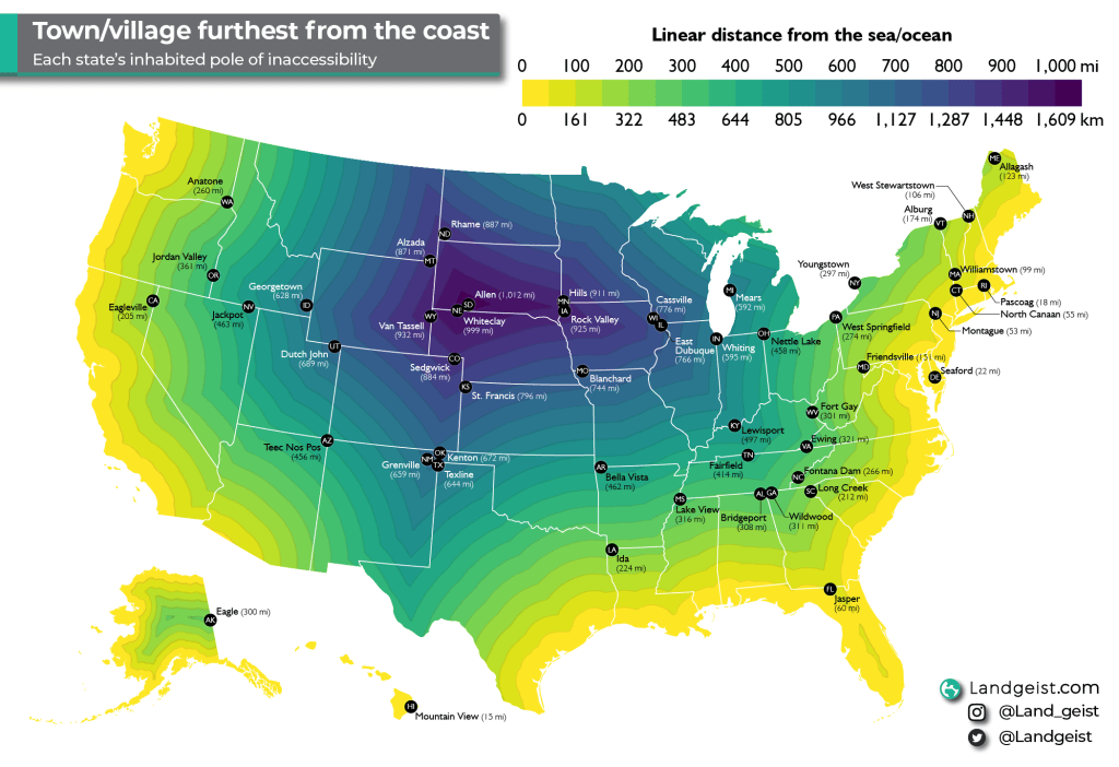
The point on land that is furthest from the sea in a linear distance, is called the pole of inaccessibility. It has nothing to do with actual access to that place. So it doesn’t take into account roads, rivers, mountains etc.
Normally this is calculated for a continent or island. For this map, we didn’t calculate the exact point of inaccessibility, but the village or town that is furthest from the coast. There’s no real name for it yet, so let’s call it the inhabited pole of inaccessibility. For most states, their pole of inaccessibility and their inhabited pole of inaccessibility are at the same location or very close to one another.
North America’s inhabited pole of inaccessibility
The furthest point from the coast in all of North America, is located in South Dakota. It is just north of the village of Allen in the Pine Ridge Reservation. The village of Allen itself, is the furthest inhabited place from the sea at 1,012 mi (1,629 km). It’s not just the inhabited pole of inaccessibility in the US, but of all of North America.
The coastline paradox
Before you get all excited, I have to let you know that for some states the pole of inaccessibility can vary slightly depending on what definition of a coastline you use. These are mostly the states closer to the coast or on an island.
Now you might be thinking, the definition of where the coast is, is pretty clear, right? Well, no. This is what’s called the coastline paradox. It’s the counter-intuitive observation that the coastline of a landmass does not have a well-defined length. It strongly depends on the method used to measure the coastline and the degree of cartographic generalization.
Furthermore, it’s also not very clear where the sea starts and ends. First of all, where the sea meets the land constantly changes because of the tides. Then there are other problems, like where does a river exactly meet the sea? How about tidal rivers? How about tidal plains?
How about the Great Lakes?
For some people, especially those living close to the Great Lakes, the Great Lakes feel like they are a sea. They are massive in size, have deep waters, beaches, rolling waves, several ports and a lot of shipping activity. However, these characteristics are not used to define what is a sea and what is a lake. There are 2 important characteristics that a body of water needs to meet to even be remotely considered a sea:
- It has salt water
- It has a connection to the ocean that is completely at sea level
Let’s look at the first characteristic. The Great Lakes have a salinity of 0.05. Anything below 0.5 is considered fresh water. The Baltic Sea, which is the sea with the lowest salinity, has a salinity of 10. So, the Great Lakes definitely don’t have salt water.
Now let’s look at the other characteristic. The Great Lakes do have a connection with the Atlantic Ocean via the St Lawrence River. However, this connection isn’t completely at sea level all the way. It starts at about 243 ft (74m) and reaches sea level at the Gulf of St Lawrence. Therefore, the Great Lakes also don’t meet this criterion and are clearly lakes.
Even the Caspian Sea, meets one of these criteria, yet is not considered a sea. It is endorheic and has salt water. However, the salinity is lower than a sea or ocean and more like a salt-lake. It is called a sea, because when the Romans first discovered it, they though it was a sea. That name has stuck ever since. Due to the Caspian Sea’s salinity, there are at least grounds for some debate to whether it’s a sea or a salt-lake. For the Great Lakes, there aren’t even any grounds to debate whether it’s a sea or not, as it doesn’t even meet any of the minimum requirements.
Although the Great Lakes might not be a sea from a geographical standpoint. I can completely understand why for many people that live or visit one of the Great Lakes, they feel like a sea to them.
Methodology
So how did I go about the calculations for this map? For this calculation, the GADM coastline dataset was used. It’s one of the most detailed freely available files of the world’s coastlines out there. Making it a great choice for accurate calculations. I’ve made some small changes to the coastline here and there, after checking it with the satellite image. A distance calculation was made from the coastline in QGIS to see which settlement is located furthest from the sea in a linear distance.
A settlement is another feature that is not as well defined as one might think. When is something a settlement and when is it just a handful of houses or farms in the countryside that are coincidentally close to each other? For this map I included a settlement if it was a city, town, township, village or census designated place. Unincorporated communities were not included, unless they are a census designated place.


Leave a comment