
Recently we had a look at Europe’s skyscrapers. This time, we’re going to have a closer look at the skyscrapers in North America.

Like this map and want to support Landgeist? The best way to support Landgeist, is by sharing this map. When you share this map, make sure that you credit Landgeist and link to the source article. If you share it on Instagram, just tag @Land_geist. On X / Twitter tag @Landgeist.
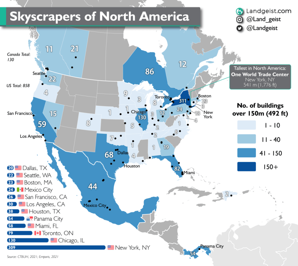
Unlike Europe, the United States is much more known for its skyscrapers. New York already has more skyscrapers than all of Europe combined.
Looking at the map, we can see that states in the US with a high population, have a significantly higher number of skyscrapers than other states. With New York, Illinois, California, Florida and Texas clearly standing out.
As we can see in the graph in the bottom left corner of the map, New York City has far more skyscrapers than any other city in North America. Chicago is second with less than half the number of skyscrapers of New York City.
Toronto has the highest number of skyscrapers of any Canadian city. Accounting for 60% of Canada’s skyscrapers.
Another non-US city that stands out, is Panama City. With 54 skyscrapers, it’s the city with the fifth largest number of skyscrapers in all of North America. Mexico City comes in ninth, with 24 skyscrapers.
Apart from the US, Canada, Panama and Mexico, the Dominican Republic has also made it onto the map with 2 skyscrapers.
The tallest building in North America is One World Trade Center in New York. With a height of 541 meters (1,776 ft).
But what exactly defines a skyscraper, you might ask? A universal definition of a skyscraper does not exist. One of the most used definitions is a building with an architectural height of at least 150 metres. That same definition is used for this map.
The data for this map is gathered from CTBUH (Council on Tall Buildings and Urban Habitat) and Emporis. In this map the definition from the CTBUH for buildings and architectural height is being applied.
Building: To be considered a building, at least 50 percent of its height must be occupiable. Telecommunications or observation towers that do not meet the 50 percent threshold are not eligible for inclusion on CTBUH’s “Tallest” lists. (Occupiable: this is intended to recognize conditioned space which is designed to be safely and legally occupied by residents, workers, or other building users on a consistent basis. It does not include service or mechanical areas which experience occasional maintenance access, etc.)
Architectural height: The architectural height measures from the level of the lowest, significant, open-air, pedestrian entrance to the architectural top of the building, including spires, but not including antennae, signage, flag poles or other functional-technical equipment. This measurement is the most widely utilized.


Leave a comment