
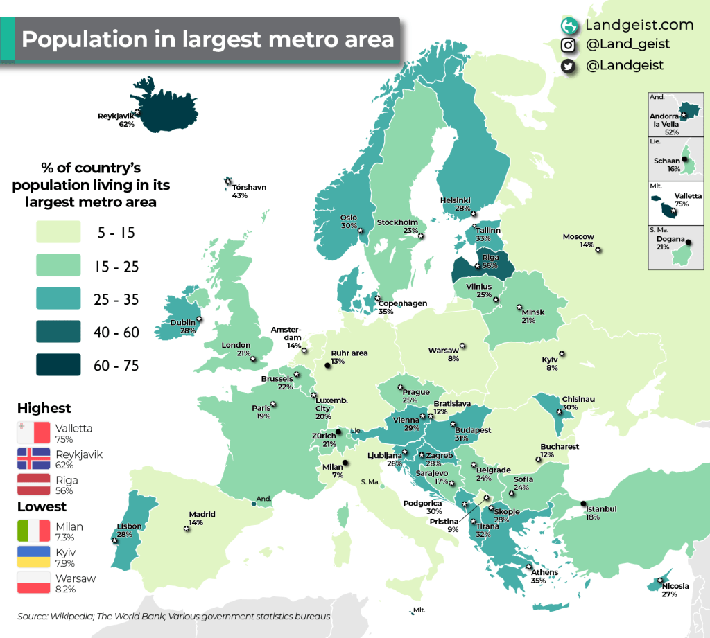
What percentage of each European country’s population lives in its largest metro area?

Like this map and want to support Landgeist? The best way to support Landgeist, is by sharing this map. When you share this map, make sure that you credit Landgeist and link to the source article. If you share it on Instagram, just tag @Land_geist. On X / Twitter tag @Landgeist.
This map gives us an interesting insight in how much of each country’s population is concentrated in its largest metropolitan area. We can see that it varies widely across Europe.
The countries with the highest concentration of its population in its largest metro area, are also the countries in Europe with one of the lowest population numbers. Iceland and Malta have the lowest population number in Europe (micro-states excluded). All of the countries where more than 40% of it’s population lives in its largest metro area, have an overall population of under 2 million.
On the other end, we see the opposite. All countries with a population of over 12 million, have less than 22% of their population living in their largest metro area. Italy, Ukraine and Poland are all in the top 10 of Europe’s most populated countries.
Two countries are not included in this map: Monaco and the Vatican. Both of these countries are city-states, where there is only one metropolitan area. In the Vatican’s case you can even argue it’s part of a foreign country’s metropolitan area, that of Rome.
There might be a few surprises on here in terms of the cities. Milan and the Ruhr area are probably the ones standing out the most. Although Rome is Italy’s largest city in terms of city proper and urban area, it is not when it comes to its metro area.
The Ruhr area is not really one city. It’s an urban area and metropolitan area made up of multiple cities like Essen, Duisburg and Dortmund. All these cities have more or less completely grown together into one massive urban area and is therefore often considered a metro area of its own. This is a bit different from the Randstad area in the west of the Netherlands. Although it consists of many metropolitan areas close to each other (e.g., Amsterdam, Den Haag, Rotterdam), it is not one big urban area where the cities have grown together. The Randstad area is a so called conurbation, an area made up of multiple metropolitan areas. The same goes for the Rhine-Ruhr Area in Germany (of which the Ruhr Area is a part)
The data for this map comes from Wikipedia and various national government statistics websites. A metropolitan area is not always clearly defined geographically. In some cases it’s very hard to speak about a metro area or even a city (e.g., Schaan, Dogana). If you would be using a different definition or source for the metro areas, you will probably and up with very similar percentages. In some cases you might even end up with different cities (e.g., Berlin instead of the Ruhr Area, Rome instead of Milan, Katowice instead of Warsaw). What I want to say with that, is that you can never get a 100% accurate picture of this dataset, but I definitely try to get as close as possible to it. And I’m pretty sure if you use different definitions, you will still get very similar percentages.


Leave a comment